How Far Can You Throw A Football?
by Lisa Hutchinson
January 2023 Newsletter
With football season winding down and the Super Bowl ahead, maybe you are wondering how this question relates to Lake Kanasatka? The key: how far is 150 feet? Keep reading to learn why this number is so important to lake health! We often share the NH boating rules for keeping 150’ from shore, docks, floats, swimmers, loons, paddlers, AND other boats when operating at greater than headway speed. 150 feet is considered the minimum distance from shore when creating a wake. Bigger and deeper-hulled boats require 300’ or more for lake health. Why 150’ or more? In addition to safety issues, boat
wakes harm the shoreline and nearshore shallows and structures, and accelerating or operating over headway speed in shallower water disturbs the lake bottom. These disruptions release more phosphorus, which feeds our
cyanobacteria blooms.
So just how far is 150 feet?
1. 50 yards, or half the length of a football field
2. Distance from the dam and boat launch to the 150’ buoy in the lake
3. 5 times the standard dock length of 30’
4. 2-3 times the distance of most floats from shore (most are 50-80’ out)
5. Length of 2 tow ropes for water skiing (most are 75’)
How far can you throw that football pass?!
If 150 Feet is the Number, Why is 20 Feet So Important?
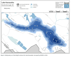
Kanasatka is a relatively shallow lake, with shallow coves, so where you are boating makes a huge difference to lake health. At the June 4 public meeting we learned that creating a wake in less than 20’ of water may cause disruption to the lake bottom, releasing more phosphorus and feeding our cyanobacteria blooms. We saw pleas last summer to move to deeper water to pull skiers or tubers or before accelerating beyond headway speed. Recent studies
show disturbance of the lake bottom up to 20’ deep. And we saw clear evidence during our core sediment sampling that the bottom was impacted at least 17’ deep. Creating larger wakes, especially operating bow up/stern down and not on plane, causes the most shoreline erosion and lakebed sediment disturbance. As part of our WMP efforts, we have a newly updated and more detailed bathymetric map. Bathymetry shows the depth of the water. White lines are marked at every 2’depth, with thicker lines every 10’ depth. Deepest spots are noted with numbers such as 28 and 46. Any area lighter blue within the 20’ depth line is less than 20’ deep at full lake level. Darker blue areas show water deeper than 20’. In all coves and many places along the shoreline, 150’ from shore is still shallower than 20’. Get to know your
bathymetry! Distance measurements are not included on this map, but here, for your consideration, are approximate distances from shore to 20’ deep water:
1. Boat launch: Over 1000’
2. Vonhurst/Birchwood Association beach: 600’
3. Sibley cove at the West End: Over 1000’
4. Camp Quinebarge point to opposite shore: only the middle 150’ of the lake exceeds 20’, the lake here is only 700’ wide
5. Coe Point Cove: 225’
6. Kilnwood Area: over 300’ from docks, 450‘ from Deer Hill Camp
7. Bishop Shore Cove: 675’
8. Maples Bay: 450’ to 975’ depending on boating route
Your LKWA and Watershed Management Plan teams
support responsible and enjoyable boating. We hope you
find this new map useful.